Table of Contents
Neighborhoods - Seadrift :
- Print, Photographic
- 1993-418-01
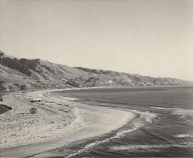
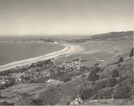
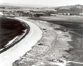
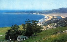
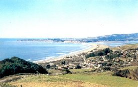
- Panoramas, Bolinas Bay
- This is an aerial panoramic view of Bolinas Bay and Stinson Beach. At the top of the picture can be seen the entrance to Bolinas Lagoon. The sandspit is seen but there are no structures on it. In the middle ground there are some houses in the town... View Full Record
- Print, Photographic
- 1993-219-01
- Panorama of Stinson Beach Patios & Sandspit
- Black and white photograph of panoramic view of Stinson Beach showing the Patios, Sandspit (Seadrift) and Bolinas Bay. It also shows the causeway to the sandspit. There are houses on the Patios and the first house on the spit-Jeffers. There are tre... View Full Record
- Print, Photographic
- 1993-144-01
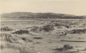
- Sandspit
- A black and white photograph of sand spit of Stinson Beach at the mouth of the lagoon, taken 1937, shows sand with clumps of dune grass in the foreground and hills in the background across a body of water. You can see the downtown Bolinas across t... View Full Record
- Print, Photographic
- 1994-165-01
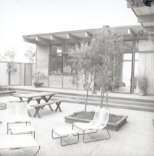
- Beach House with Patio
- This black and white photo shows a house and patio. The patio in the foreground is cement with a raised box protecting a small tree. A traditional wood picnic table and two benches is accompanied by tubular strung chairs and footstools. The house,... View Full Record
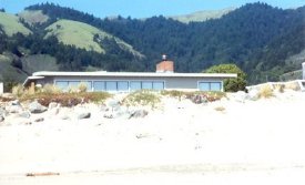
- Print, Photographic
- 2001-251-01
- McCready House
- The flat rooftop, brick chimney and tops of the windows that run the length of the McCready house are visible above the sand dunes, rip-rap and dune grasses. The house is one the the earliest homes built on the sandspit in Seadrift, located at 13 Se... View Full Record
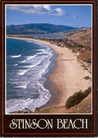
- Postcard
- 2005-111-14
- Stinson Beach
- A color photograph postcard copyrighted on 1985. The photo was taken from the hill above the Rocks, southern end of the beach showing the Rocks at lower left corner, sweep of the beach with the life guard tower of Golden Gate national Recreation Pa... View Full Record
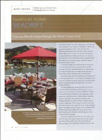
- Periodical Pages
- 2012L-102-01,02, 03, 04
- Marin At Home, Seadrift
- Descriptions of the 2nd home owned by the McCullaghs on the lagoon side of Seadrift Road in Seadrift and the background of the family who live in San Rafael.... View Full Record

- Magazine
- 2013L-100-01
- Town and Country
- This periodical issue highlights Seadrift, Stinson Beach as one of "The Three American Places to Be This Summer". The article written by Merla Zellerback and photographed by Alan Bolesta runs from page 81 to 91 with 21 photographs including photo of... View Full Record

- postcard
- 1993-190-01
- Seadrift 1955
- Color aerial photograph of Seadrift development made into postcards. There are 2 of the same postcards. The caption on the back of each postcard reads, "Sea-Drift, located in Marin County, just forty minutes from downtown San Francisco, on the natur... View Full Record
- Print, Photographic
- 1993-241-01
- First houses on Seadrift
- This black and white photograph is of the tip of the sandspit looking toward town of Stinson Beach from Bolinas. There is one road running past the first few houses in Seadrift and telephone poles. The entire sweep of the beach is shown with the hi... View Full Record

- Print, Photographic
- 1993-263-01
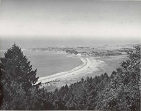
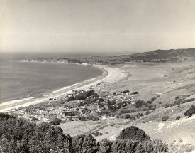
- Bolinas Bay
- This black and white photograph shows a panoramic view of the town of Stinson Beach and Bolinas Bay. Photo taken from Panoramic Highway. The first houses of Seadrift Subdivision are at top of photo: Adelaide Mc Cready, Admiral King, and Wayne &... View Full Record
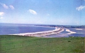
- print,photographic
- 1993-265-01
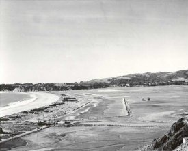
- Continuing filling for Dipsea Rd. and Seadrift Lagoon
- A black and white photograph of the area of Bolinas Lagoon in the process of being filled in in order to create Dipsea Rd. and the Seadrift Lagoon. Part of the causeway between Highway 1 and Seadrift is visible .... View Full Record
- Print, Photographic
- 1993-266-01
- Start of filling for Dipsea Rd. and Seadrift Lagoon
- A black and white photograph of the area of Bolinas Lagoon being filled in order to create Dipsea Rd. and Seadrift Lagoon at the beginning of the project. There is a dredge in the right mid-ground. The causeway between Highway 1 and Seadrift is visib... View Full Record
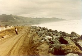
- Print, Photographic
- 1993-304
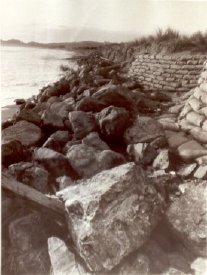
- Rock wall (rip-rap) at Seadrift
- In this black and white photograph we see a strip of large rocks piled between sand bags protecting dunes on the right and the ocean on the left on the Seadrift subdivision portion of the beach.... View Full Record
- Print, Photographic
- 1993-335-01
- Bolinas Bay
- A panoramic westerly view of Bolinas Bay and Stinson Beach town from the foothills of Mt. Tamalpais. The Bolinas Lagoon is visible in the right upper corner with the Bolinas peninsula above it stretching across the whole upper part of the picture. A... View Full Record
- Print, Photographic
- 1993-336-01
- Panoramic view of Bolinas Bay
- This black and white photograph shows a panoramic westerly view of Bolinas Bay and the town of Stinson Beach. Bolinas Bay and Lagoon are visible with the Bolinas peninsula stretching across the upper part of the picture. In the town of Stinson Beach,... View Full Record
- Print, Photographic
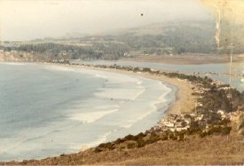
- 1993-769
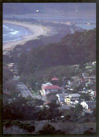
- Stinson Beach Town
- This color aerial photograph of the town of Stinson Beach is mounted on cardboard. It shows the beach itself and the bay in the upper left corner with the sandspit as far as the end of the man-made Seadrift lagoon and the Seadrift houses paralleling... View Full Record
- Print, Photographic
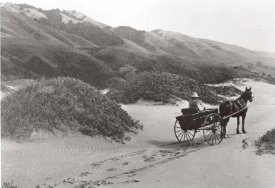
- 1993-863-01
- A Baggy on Sandspit
- A 8x10 copy of the original photographic print by Edgar A. Cohen, signed in black on lower left. A horse and buggy with a lady driver in hat heading off to the right. Horse & buggy tracks show her path that has passed dunes covered with grass with th... View Full Record
- Print, Photographic
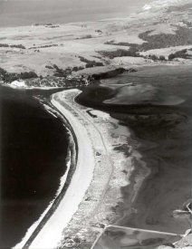
- 1994-415-01
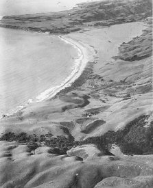
- Bolinas Lagoon Overview
- Overview of Bolinas Lagoon and Seadrift Sandspit. There is a road down the middle of the sandspit and 2 or 3 structures visible from the air. On the far side is the broad and basically barren Bolinas Mesa, although trees and some structures are visib... View Full Record
- Print, Photographic
- 1994-416-03
- First houses on Seadrift
- Overview of Seadrift Sandspit where the first houses are visible. We see the sandy beach on the left of the spit and the shallow lagoon on the right. The sandspit is sparsely vegetated and has a dirt road traversing the middle. There is one house... View Full Record
- Postcard
- 1997-109-01
- Seadrift Panorama
- Color postcard of "SEA DRIFT" A sand spit on the Pacific Ocean north of San Francisco, extending from Stinson Beach, Marin County, California. Clouds cover the western slopes of Mt. Tamalpais." Also written on the back in ink: "I bought this card.... View Full Record
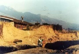
- Print, copy
- 1998-128
- Beach Erosion
- Erma Parsons stands on bended knee, one arm resting on a wooden sign, in front of deeply eroded sand dunes in Seadrift. The upper part of a beach house can be seen above her near the dune edge. A large wooden beam protrudes several feet from the l... View Full Record
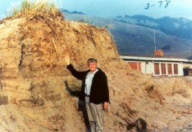
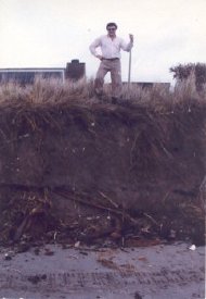
- Print, copy
- 1998-129
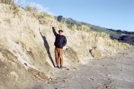
- Beach Erosion
- Denis Parsons stands in front of an eroded dune, approximately twice his size, with his righthand arm raised indicating the erosion. He is wearing a black jacket over a light blue shirt with khaki trousers. Dune grass is visible on the top of the d... View Full Record
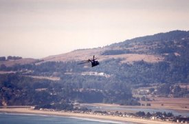
- Print, Photographic
- 1998-284-01
- Helicopter
- This color photograph is an aerial view looking across the shoreline of a sand spit with a lagoon on the other side and the land behind rising up to a wooded hill. There is a helicopter at the center of the photo, silhouetted against the hillside.... View Full Record
- Booklet
- 1998L-102-01
- Seadrift Lagoon, Stinson Beach, Marin County, California
Protective Restrictions
- 1. Map and photographs of new building sites opened up by the William Kent Estate Co. along the Seadrift Lagoon accessible by the Dipsea Road known as Seadrift Lagoon Subdivision No. Two.
2. The list of restrictions, conditions, covenants and agre... View Full Record
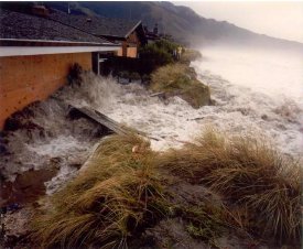
- Print, Photographic
- 1999-204-01
- 1983 Storm
- Waves crash againt the exterior of the George Hartman house (314 Seadrift Road) and over the dune grasses. The waves are foamy white and carry boards/fencing up against the house. All along the Seadrift beachfront waves eat away at the dunes. Two p... View Full Record
- Print, Photographic
- 2000-104-01
- Storms of 1983 Seadrift
- The view is toward the south, in the vicinity of 178 Seadrift Road. One person stands in a "road" that was created by front loaders, which placed rip rap rock along the top edge of the dunes to the eroded beach below to protect the houses from the i... View Full Record
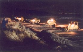
- Print, Photographic
- 2000-105-01
- Storms of 1983 Seadrift
- One man stands looking down on several front loaders working on the beach to restore the end of Seadrift sandspit after winter storms of 1983. They are moving sand from the beach and depositing it over rip rap in front of the houses to form a dune,... View Full Record
- Print, Photographic
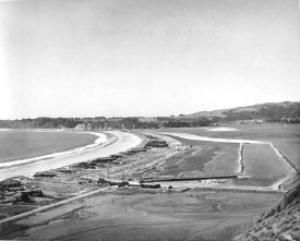
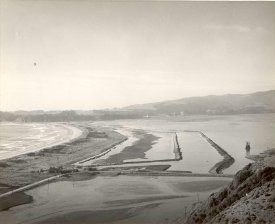
- 2001-160-01
- Kent Fill for Inner Lagoon
- Overhead panoramic photo of Seadrift in the making with the Bolinas Ridge in the background. Back of photo reads: Feb 1961 - [Intermediate] Kent Fill For Dipsea Rd, Inner Lagoon. We see a long curving strip of land/sand dotted with a series of pol... View Full Record
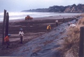
- Print, Photographic
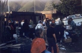
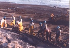
- 2003-492
- Oil Spill, Jan 1971
- A color photographic print made from a slide showing Seadrift beach at the end of sandspit. Bolinas beach is shown in the back. Shows many people with cardboard boxes, probably gathering dead and oiled birds. There are straw bales scattered to catch... View Full Record
- Print, Photographic
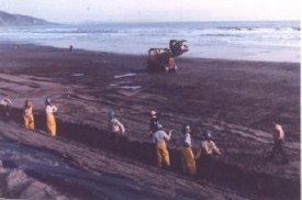
- 2003-493
- Oil Spill, Jan 1971
- A color photographic print made from a slide showing Seadrift beach at the end of sandspit. Bolinas beach is shown in the back. Shows many people standing and working. There are straw bales scattered to catch oil on the surf edge of the beach.... View Full Record
- Print, Photographic
- 2003-511
- Oil Spill, Jan 1971
- A color photographic print made from a slide showing many men and women helping oil covered birds. They are assembled in the parking area outside of the Seadrift Office (also used as the Fire station office at the time) where a motor boat is also p... View Full Record
- Print, Photographic
- 2004-100-02
- Cliff in front of 292 Seadrift Rd
- A colored photograph of a man standing at the top of the cliff about 10 ft high created by the erosion of the sand by the storm wave action. Two houses are seen in the back of the man who hold a stick probably the handle of shovel. Written on the bac... View Full Record
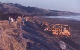
- Print, Photographic
- 2004-100-05
- Pushing up sand
- See 2004-100-04. Perhaps this is a Little more dramatic photo of the same subject. 4 bulldozers are in line along the wall.... View Full Record
- Print, Photographic
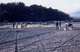
- 2004-100-06
- Cloth is laid down
- A color photograph depiction black plastic cloth underlayment are being laid on top of the pushed up sand base. A group of workers, probably some members of California Conservation Corps among the workers. Bolinas point and surf of the Stinson is on... View Full Record
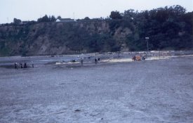
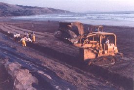
- Print, Photographic
- 2004-100-07
- Cloth is laid down
- Color photograph looking toward beach from the top of rock wall being built at Seadrift. 10 workers, probably the California Conservation Corps group, are lined up at the bottom of the sand pushed up against the erosion and laying down the black plas... View Full Record
- Print, Photographic
- 2004-100-08
- Cloth is laid down
- See 2004-100-07. In this picture the group of the Calif. Conservation Corps workers are holding up a long piece of drift fence probably to stop further tidal erosion at the heal of the slope. A bulldozer is moving along the surf.... View Full Record
- Print, Photographic
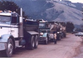
- 2004-100-09
- Rocks are brought in
- Colored photograph of 3 dump trucks with load of rocks are lined up on Seadrift Rd. On the very far back of the road, another truck is turning around. The hill of Stinson Beach Gulch is seen on the background. On the back of the photo written in pen:... View Full Record
- Print, Photographic
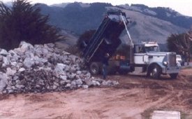
- 2004-100-10
- Rocks are brought in
- A white dump truck is dumping rocks on the beach at the end of Seadrift. The Stinson Beach Gulch hills in the background.... View Full Record
- Print, Photographic
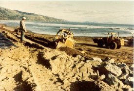
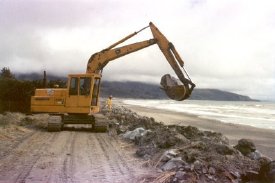
- 2004-100-11
- Rocks are put on cloth
- A bulldozer is putting a huge rock on top of the cloth laid on top of the sloped sand. 3,4 people are standing on top of the slope , in the dune grass. Photo is taken looking toward San Francisco. The hills toward San Francisco is on the background... View Full Record
- Print, Photographic
- 2004-100-13
- Rocks are put on cloth.
- A bulldozer is laying a huge rock on top of the black plastic cloth laid on the sand. The bulldozer stand behind the drift fence and its arm reaches over the fence. 10 workers are working on the fence in distance. The shore of Stinson Beach toward Sa... View Full Record

- Print, Photographic
- 2004-100-14
- Rocks are put on cloth
- See 1004-100-13. This photo is looking toward the beach, looking straight at the front of a bulldozer with a load of rocks about to be placed. Second bulldozer with empty bucket is behind moving to east.... View Full Record
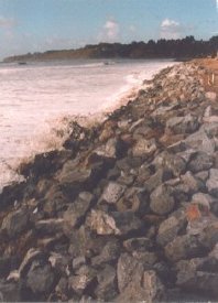
- Print, Photographic
- 2004-100-15
- Rock Wall before grooming
- Photograph of the beach and the rock wall looking toward Bolinas point. On the back of photo is written:Rock wall finished before "grooming". The white surf is just caressing the toe of the rock wall.... View Full Record
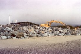
- Print, Photographic
- 2004-100-16
- Grooming Rock Wall
- Photo looking at the Rock wall from the top of erosion, in front of houses. A bulldozer is working on top of the wall, now, rearranging stray rocks. A house, perhaps the Lowrey's stands behind.... View Full Record
- Print, Photographic
- 2004-100-17
- The home owner
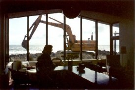
- Inside of the house on 2004-100-15. A woman sit by the window, pensively, looking the bulldozer grooming the rock wall just outside. The interior is back lit. You can see the surf beyond.... View Full Record
- Print, Photographic
- 2004-100-18
- Grooming rock wall
- A buldoser is picking or placing a large rock. A work man stands by. They are working from the top of the wall, replacing rocks to right position. On the back of photo is written:8. Grooming rock wall.... View Full Record
- Postcard
- 2004-101-01
- Stinson Beach Postcard
- A color postcard of Stinson Beach early 1960. A blue sky day with Bolinas in the background, shows Seadrift lagoon and the developments on the Seadrift Road side. The downtown area developments shows the Sea Beach Hotel (Grand Hotel) which burned dow... View Full Record
- postcard
- 2004-102-01
- Stinson Beach 1990's
- A color postcard of Stinson Beach panorama c. 1990. The view is taken from above the Panoramic Highway with dry summer hills and Panoramic Highway in forground, showing houses on the Old Town hills. The Post Office and Shakespeare on the Beach comple... View Full Record
- Postcard
- 2004-102-02
- White Gate Ranch 1970
- A color postcard of Stinson Beach from White Gate Ranch. Blue Sky, Blue Ocean along crescent of the beach and the Seadrift Lagoon with no houses on the Dipsea side. The Patios, Calles and houses in the Old Town and Highlands are visible. The Ranch bu... View Full Record
- Print, Photographic
- 2004-116-01
- 1973 Storm Sand Cliff
- A print made from a color slide. Otto Reutinger is standing in front of sand bank eroded after the storm of 1973. He is standing in front of Seadrift area with his right hand reaching out to the top of the cliff. He is wearing a black beret hat, dark... View Full Record
- Postcard
- 2005-101-01
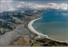
- Stinson Beach / Bolinas Lagoon
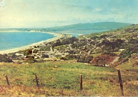
- Aerial photograph postcard of Stinson Beach and Bolinas Lagoon from the tip of Bolinas Mesa to San Francisco. The hills behind the Beach and Marin Headland are also shown. White thunder clouds float on top of all. It reads on the back; Stinson Beach... View Full Record
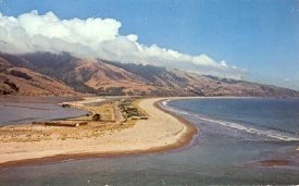
- Postcard
- 2005-101-02
- Pacific Coastlands
- A color postcard of Stinson Beach taken from hills along the Panoramic Highway including the beach, Seadrift development, downtown Stinson Commercial developments and old town hills. On the backside of the postcard, it says; Pacific Coastlands, The v... View Full Record
- Postcard
- 2005-111-10
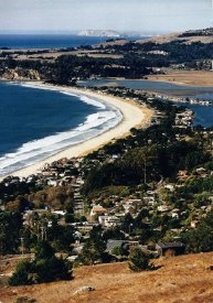
- Stinson Beach Panorama 1950s
- A colored photo postcard from the 1950s. The photo is taken from White Gate Ranch and includes Bolinas peninsula, Lagoon, Bay and the town of Stinson Beach with its houses. Shows early development of Seadrift without its lagoon and the first 2 houses... View Full Record
- Postcard
- 2005-111-12
- Seadrift and Bolinas Lagoon
- A color photo postcard . The photo was taken from the hill near the Highland Water Tank showcases the Seadrift development with its lagoon between the pacific ocean and the Bolinas Lagoon. On its back the caption reads: Stinson Beach, California. Se... View Full Record

- Postcard
- 2005-111-13
- Seadrift and Stinson Beach
- A color photograph postcard of Stinson Beach taken from air above Bolinas. Shows the Bolinas beach and the channel in the very foreground, the whole Seadrift subdivision with houses and hills around the Stinson School and the Stinson Beach County Wa... View Full Record
- Print, Photographic
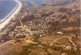
- 2010-109-01
- Stinson Panorama 1980s
- A color photographic print of Stinson Beach and vicinity taken from Dipsea Trail. It is taken in the morning of a fair day. Hills are just starting to take yellow of summer color. It shows Bolinas Mesa, the Little Mesa, Bolinas Lagoon and the beach o... View Full Record
- Postcard
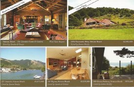
- 2012A-109-07
- Properties Ad
- a postcard generated by Highway One Properties listing five properties for sale by Sandra di Grazia and Jeanne Sherfey.;... View Full Record

- Advertisement
- 2012A-109-09
- Recent Sales
- A flyer by Seadrift Co. Realty of five recent sales consisting of two parcels in Seadrift, two houses in Seadrift and one house on Calle del Sierra... View Full Record
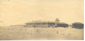
- Print, Photographic
- 1993-346-01
- Dipsea Inn
- An original black and white photographic print of Dipsea Inn by Edgar A. Cohen. Shows the Dipsea Inn and 2 cottages as stood on Sandspit of Stinson Beach. Bolinas Mesa and surf in background, sandy beach with posts (Property mark?) in front. On the... View Full Record
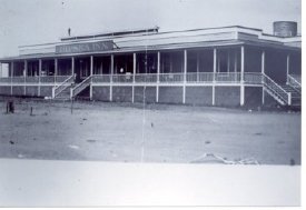
- Print, Photographic
- 1993-347-01
- Dipsea Inn
- The photo is of a long, low building on the sand. There is a long veranda with stairs down to the beach at the right end and in the middle under a sign reading Dipsea Inn.... View Full Record
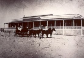
- Print, Photographic
- 1993-348-01
- Dipsea Inn
- The photo shows the long low structure known as the Dipsea Inn with a horse drawn carriage (4 horses) on the sand in front of the building. There appear to be 4 people in the carriage and 2 people on the veranda of the inn.... View Full Record
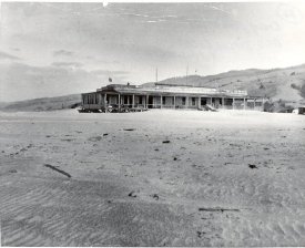
- Print, Photographic
- 1993-169-01
- Dipsea Inn
- This black and white photograph shows a long,low building with many windows and a porch running the length of it. There are hills in the background and a sandy beach in front. The photo is of the Dipsea Inn in early 1900s.(1905-06). It was built in... View Full Record