Accession#:
2012A-101
Title:
Map C
Area / Region:
Stinson Beach
Publisher:
Stinson Beach Planing Group
Pubication Date:
1960s
Language of Material:
English
Size:
8.5x11
Medium:
Print
Scale:
1"=!00'
Catalog Date:
03/06/2012
Collection:
SBHS Archival Collection/Map Collection
Creator:
Organizations/ Stinson Beach Planing Group
Dates of Creation:
1960s, before GGNRA took over the State Park in 1972
Map Language:
English
Scope & Content:
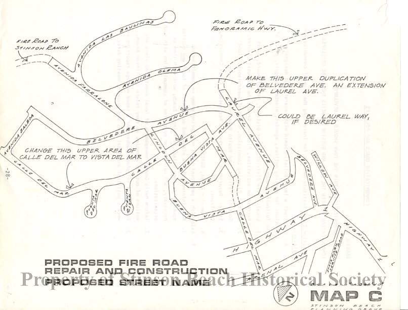
Proposed Fire Road Repair and Construction and Proposed Street Name named Map C was a page of book made to the public by the Stinson Beach Planning Group, predecessor of Stinson Beach Village Association. It proposes existed fire roads to Stinson Ranch from Avenida Farralone, Laurel Avenue to Panoramic Highway and the upper Calle del Mar to the lower Calle del Mar to be improved . For naming of the streets it proposed the upper Calle del Mar to be renamed Vista del Mar, Make upper Belvedere Avenue to become an extension of Laurel Avenue.
Search Terms:
1960s
Fire Road
Stinson Beach
Streets
Maps
Fire Road
Stinson Beach
Streets
Maps
Click to Enlarge
 MapC Fire Roads Repair, Street Rename
 MapC Fire Roads Repair, Street Rename