Accession#:
2012A-101
Title:
Map B Proposed Causeway for Stinson Beach Emergency Access
Area / Region:
Stinson Beach
Projection:
Unknown
Publisher:
Stinson Beach Planing Group
Publication Place:
Stinson Beach
Pubication Date:
1960s
Language of Material:
English
Size:
8.5x11
Medium:
Print
Scale:
1"=100'
Catalog Date:
03/06/2012
Collection:
SBHS Archival Collection/Map Collection
Creator:
Organizations/ Stinson Beach Village Association
Dates of Creation:
1960s, before GGNRA took over the State Park in 1972
Map Language:
English
Scope & Content:
Proposed Causeway for Stinson Beach Emergency Access named Map B was a page of book made to the public by the Stinson Beach Planning Group, predecessor of Stinson Beach Village Association. It proposes existed dirt service road to Seadrift from Shoreline Highway to be paved, realign the Lagoon Channel, and build a bridge at the Shoreline Highway end.
Search Terms:
1960s
Maps
Seadrift
Seadrift Causeway
Maps
Seadrift
Seadrift Causeway
Click to Enlarge
 MapB Proposed Seadrift Emergency Causeway
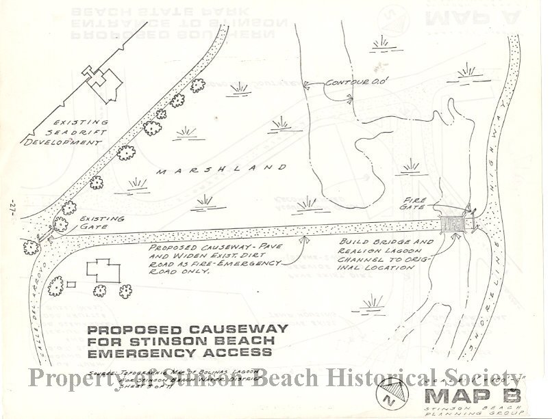 MapB Proposed Seadrift Emergency Causeway