Accession#:
2011A-103
Date:
1873
Title:
Map of Marin County, California Completed by H. Austin from Official Surveys and (Illegible) Drawn by F. Whitney 1873
Area / Region:
Marin County, California
Insets:
Town of San Rafael, Tomales, and Nicasio
Publisher:
A.L. Bancroft Co. and Ltd.
Publication Place:
San Francisco, Ca
Pubication Date:
1873
Size:
41 x 42
Medium:
Paper
Scale:
1 mile to 1 inch
Related Units of Description:
1994A-103
Catalog Date:
07/12/2011
Collection:
SBHS Archival Collection/Map Collection
Creator:
Austin, H.
Dates of Creation:
1973
Map Language:
English
Scope & Content:
Map of Marin County printed in brown ink and mounted on a card board. It identifies 8 townships exiting then within the Marin County boundary in 1873 and many school districts within the townships. It also shows individual land holders by names and their subdivided site maps. It includes beside usual roads, rail roads; statistics of: 1872 Value of real estates, value of personal property, total population in 1870, 1860 and 1850. It also shows relations to the Mexican Grants. Enlarged map of San Rafael, Tomales and Nicasio are at the bottom of this map.
Search Terms:
1873
Maps
Marin County
Town & Country
Tomales
San Antonio
Nicasio
Novato
San Rafael
San Rafael School District
San Quentin School District
Sausalito
Sausalito School District
Point Reyes
Bolinas
Maps
Marin County
Town & Country
Tomales
San Antonio
Nicasio
Novato
San Rafael
San Rafael School District
San Quentin School District
Sausalito
Sausalito School District
Point Reyes
Bolinas
Click to Enlarge
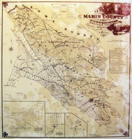 Marin County Map 1873
 Marin County Map 1873