Accession#:
2001-160
Title:
Kent Fill for Inner Lagoon
Date:
Feb 1961-Feb 1961
Catalog Date:
10/17/2008
Category:
8: Communication Artifact
Classification:
Neighborhoods
Seadrift,Sandspit
Sandspit
Bolinas Lagoon
Seadrift,Sandspit
Sandspit
Bolinas Lagoon
Collection:
SBHS Photo Collection
Copyright:
SBHS
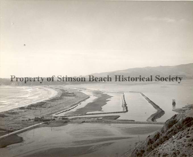
Description:
Overhead panoramic photo of Seadrift in the making with the Bolinas Ridge in the background. Back of photo reads: Feb 1961 - [Intermediate] Kent Fill For Dipsea Rd, Inner Lagoon. We see a long curving strip of land/sand dotted with a series of poles extending the length of it. Plots of land are demarcated by what appear to be groves of trees. To the right of the strip of land and extending out from it are two raised lines of earth that form parallel curves creating a channel around the sandspit, The inner portion of the first "channel" has formed a sandbar.
Event:
Panorama
Film Size:
35 mm
Medium:
Photographic Paper
Object ID:
2001-160-01
Object Name:
Print, Photographic
Orig/copy:
Original
Place:
Seadrift (Sandspit)
Print Size:
8" x 10"
Source:
Engel, Albert
Subjects:
Neighborhoods-Seadrift (Sandspit)
Sandspit
Seadrift
Bolinas Lagoon
Sandspit
Seadrift
Bolinas Lagoon
Click to Enlarge