Accession#:
1993-516
Title:
Seadrift, Calles, and Patios
Catalog Date:
09/05/2003
Category:
8: Communication Artifact
Classification:
Aerials
Collection:
SBHS
Copyright:
SBHS
Description:
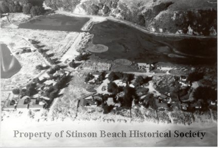
Overhead view, as if from a small aeroplane, of the Stinson Beach area known as the Calles, Patios and Seadrift. The shoreline appears at the botton of the photograph with the dunes in front of the oceanfront houses, at least nine of which can be seen. At the top is Highway 1 and midway what appears to be a causeway leading towards the Seadrift development which is just beginning. The little lagoon partially shows on the extreme left between the shoreline and the highway. About four major structures appear among trees near the junction of Seadrift and Dipsea roads.
Film Size:
35mm
Frame #:
7
Medium:
Photographic Paper
Negative #:
5
Object ID:
1993-516-01
Object Name:
print,photographic
Print Size:
4"x6"
Source:
Kent, Bill
Subjects:
Neighborhood-Calles and Patios
Neighborhoods-Seadrift (Sandspit)
Neighborhoods-Seadrift (Sandspit)
Click to Enlarge
 Neighborhoods-Seadrift, Calles
 Neighborhoods-Seadrift, Calles