Accession#:
1993-190
Title:
Seadrift 1955
Date:
1955-1962
Catalog Date:
06/04/2002
Category:
8: Communication Artifact
Classification:
Aerials
Beach
Bolinas Bay
Bolinas Lagoon
Causeway
Marin County
Seadrift,Sandspit
Postcard
Beach
Bolinas Bay
Bolinas Lagoon
Causeway
Marin County
Seadrift,Sandspit
Postcard
Collection:
SBHS
Copyright:
SBHS
Description:
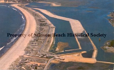
Color aerial photograph of Seadrift development made into postcards. There are 2 of the same postcards. The caption on the back of each postcard reads, "Sea-Drift, located in Marin County, just forty minutes from downtown San Francisco, on the natural sand-split between Stinson Beach and Bolinas. Sea-Drift Lagoon is land-locked. The water level is controlled and protected for sailing and swimming. The Pt. Reyes National Sea Shore lies (just) a few miles to the Northwest. Color photo by Aero Photographers, Inc." It is printed by Natural Color by Mike Roberts, Berkley 2, Calif.
Note the secondary lagoon to East where the Dipsea Road side of the development now exists, and the causeway to the Highway 1 which was removed in the1960s. See notes.
Note the secondary lagoon to East where the Dipsea Road side of the development now exists, and the causeway to the Highway 1 which was removed in the1960s. See notes.
Event:
Scenery
Frame #:
9
Medium:
Paper/Postcard
Negative #:
26
Notes:
The Point Reyes National Seashore was established in1962, which makes the date of this photograph, 1955 -1958, somewhat questionable.
Object ID:
1993-190-01
Object Name:
postcard
Photographer:
Aero Photographers Inc.
Place:
Neighborhoods/Seadrift(Sandspit)
Print Size:
3 1/2 x 5 1/2
Source:
Engel, Albert
Studio:
Natural Color Mike Roberts, Berkeley 2, Calif
Subjects:
Bolinas Lagoon
Neighborhoods-Seadrift (Sandspit)
Beach (on Bolinas Bay)
Neighborhoods-Seadrift (Sandspit)
Beach (on Bolinas Bay)
Year Range from:
1955
Year Range to:
1962
Click to Enlarge